

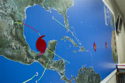
The wall map at the National Hurricane Center in Miami shows the location of hurricanes Karl, Igor and Jula Thursday, Sept. 16, 2010. Karl has become a hurricane in the Gulf of Mexico after dumping heavy rains on the Yucation Peninsula as a tropical Storm. In the Atlantic, Igor spun into a dangerous Category 4 storm that could bring dangerous rip currents to the U.S. East Coast. On the other side of the Atlantic, Julia briefly intensified into a powerful Category 4 storm before weakening to a Ca (AP Photo)
MIAMI (AP) — Karl has become a stronger hurricane in the Gulf of Mexico after dumping heavy rains on the Yucatan Peninsula as a tropical storm.
The Mexican government issued a hurricane warning for a 186-mile (300-kilometer) stretch of coast in Veracruz state, stretching northward from the city of the same name. On its predicted path, Karl could make landfall between the port of Veracruz and the oil hub of Poza Rica.
Karl’s maximum sustained winds were near 100 mph (160 kph) late Thursday. That makes it a Category 2 storm.
The National Hurricane Center in Miami says additional strengthening is possible and Karl could approach major hurricane strength before making land sometime Friday.
Karl is located about 210 miles (335 kilometers) east-southeast of Tuxpan, Mexico, and is moving west near 9 mph (15 kph).